This is a great site for information

The Canadian Hydrographic Service
Central and Arctic Region
http://www.waterlevels.gc.ca/C&A/bulletin_e.html
Lake Erie
 Lake Erie is the fourth largest lake (by surface area) of the five Great Lakes in North America, and the thirteenth largest globally. It is the southernmost, shallowest, and smallest by volume of the Great Lakes and therefore also has the shortest average water residence time. It is bounded on the north by the Canadian province of Ontario, on the south by the U.S. states of Ohio, Pennsylvania, and New York, and on the west by the state of Michigan. The lake is named after the Erie tribe of Native Americans who lived along its southern shore.
Geography
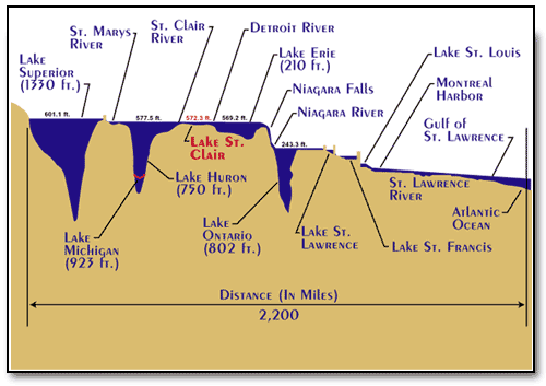
Lake Erie (42.2° N, 81.2° W) has a mean elevation of 571 feet (174 m) above sea level. It has a surface area of 9,940 square miles (25,745 km²) with a length of 241 miles (388 km) and breadth of 57 miles (92 km) at its widest points.
It is the shallowest of the Great Lakes with an average depth of 62 feet (19 m) and a maximum depth of 210 feet (64 m). For comparison, Lake Superior has an average depth of 483 feet (147 m), a volume of 2,900 cubic miles (12,100 km³) and shoreline of 2,726 miles (4385 km). Because it is the shallowest, it is also the warmest of the Great Lakes.
Lake Erie is primarily fed by the Detroit River (from Lake Huron and Lake St. Clair) and drains via the Niagara River and Niagara Falls into Lake Ontario. Navigation downstream is provided by the Welland Canal, part of the Saint Lawrence Seaway. Other major contributors to Lake Erie include the Grand River, the Huron River, the Maumee River, the Sandusky River and the Cuyahoga River.
Point Pelee National Park, the southernmost point of the Canadian mainland, is located on a peninsula extending into the lake. Several islands are found in the western end of the lake; these belong to Ohio except for Pelee Island and 8 neighboring islands, which are part of Ontario. The cities of Buffalo, New York; Erie, Pennsylvania; Toledo, Ohio; Port Stanley, Ontario; Monroe, Michigan; and Cleveland, Ohio are located on the shores of Lake Erie.
Hydrology
Lake Erie has a lake retention time of 2.6 years, the shortest of all the Great Lakes.
Lake Erie's water level fluctuates with the seasons as in the other Great Lakes. The lowest levels are in January and February, and the highest in June or July. The average yearly level varies depending on long-term precipitation.
Short-term level changes are often caused by seiches that are partcularly high when southwesterly winds blow across the length of the lake during storms. These cause water to pile up at the eastern end of the lake. Storm driven seiches can cause damage onshore. During one storm in November 2003, the water level at Buffalo rose by 7 feet (2.1 m) with waves of 10-15 feet (3-4.5 m) for a rise of 22 feet (6.7 m). Meanwhile, at the western end of the lake, Toledo experienced a similar drop in water level.
Water Levels
Historic High Water The lake fluctuates from month to month with the highest lake levels in October and November. The normal highwater mark is 2.00 feet (0.61 m) above datum (569.2 ft or 173.5 meters). In the summer of 1986, Lake Erie reached its highest level at 5.08 feet (1.55 m) above datum. The high water records were set from 1986 (April) through January of 1987. Levels ranged from 4.33 feet (1.32 m) to 5.08 feet (1.55 m) above Chart Datum.
Historic Low Water Lake Erie experiences its lowest levels in the winter. The normal lowwater mark is 1.50 feet (0.46 m) above datum (569.2 ft or 173.5 meters). In the winter of 1934, Lake Erie reached it's lowest level at 1.50 feet (0.46 m) below datum. Monthly low water records were set from July 1934 through June 1935. During this twelve month period water levels ranged from 1.50 feet (0.46 m) to the Chart Datum.
This is a great map illustration check it out